Hiking Kinnard Creek Trail in Oconee National Forest

The Oconee National Forest has been part of the Chattahoochee-Oconee National Forest almost since its establishment.
But it’s much smaller, much different, much less well-known, and much more divided up than the Chattahoochee National Forest in North Georgia.
While open to all uses (like all National Forests), the Oconee National Forest is absolutely more focused on hunting, horses, and timber harvesting than hiking, camping, biking, or any other activity.
And yet, the Oconee National Forest is –
- very close to Atlanta
- has much, much less use than any other district of the Forest (outside of deer season)
- has a unique, an increasingly endangered ecosystem
- the historic heart of Georgia – all the way back to before European Settlement
So I decided to start day hiking the Oconee National Forest. But I found that there is *very* little good information on the Internet.
*I’ve since checked out other middle Georgia public lands like the Piedmont National Wildlife Refuge, Burgess Mountain Trail, Murder Creek, Scull Shoals, and the Hitchiti Trail.
The best resources I found were The Forest Service’s Interactive Visitor Guide and their PDF maps in addition to a good cached but basic topo layer map from Google Maps.
Either way, I wanted the Internet to have more “on the ground” information, hence, this detailed post.
Here’s an overview of my hike on the Kinnard Creek Trail in the Oconee National Forest.

The trailhead at a hunt camp off Concord Church Rd. If you turn off GA Hwy 16, it’s pretty easy to see.
There is plenty of parking, and lots of evidence of use, even though basic things like the information sign is missing.

I went 2 weeks after deer season, and the hunt camp looked pretty trashed. The area is heavily used during hunting season, so be sure to bring an orange vest in the Fall.

The Kinnard Creek trail has an extension towards the back of the hunt camp. But that way is overgrown in the Winter and doesn’t go anywhere of note.
Instead, I went back to the road and turned right. The actual trail begins about a hundred feet down the road.

There is a very old trail marker and a clear path through some young pine.
Right from the beginning, I got a sense that the Oconee is a real *working* forest. Plenty of harvesting going on.
But the ironic thing is that most of the clear cutting is on private land. In fact, inholdings* seem to make up most of the Forest. I encountered a lot of Property Boundary markers and lots of boundary paint throughout the hike. There’s no free direction bushwhacking without GPS and a zoomed in land boundary map.

*Aside on inholdings. US Congress designates a National Forest boundary. But most land east of the Mississippi was already sold / deeded before the National Forest System. The Forest Service has budget & authorization to buy land within National Forest boundaries. Ironically though, the National Forests have restored cut-over, worthless land left from the Great Depression, so land values are high again. Combined with budget cuts & raiding of the Land & Water Conservation Fund, most Eastern National Forests look like swiss cheese on a boundary map. The books Wilderness Warrior & Rightful Heritage are incredible reads on the history of public lands & conservation.
Right at the beginning of the hike, I messed up. There is a service path that bears to the left and goes down to a closed Forest Service Road. That is not the Kinnard Creek Trail. The trail is obliterated for a segment from storm damage & clear cutting.

I bore left on the much easier “trail” that ended up joining up with the closed Lower Concord Chruch Road. There was no signage or indication that it wasn’t the Kinnard Creek Trail.
As show in the picture above, you actually have to bear right to cross over Lower Concord Church Rd to continue on Kinnard Creek Trail. The trail has horse & bike signage once you’ve crossed.
In hindsight, it might actually be easier to drive & park on the beginning of Lower Concord Church Rd and just start the trail there.
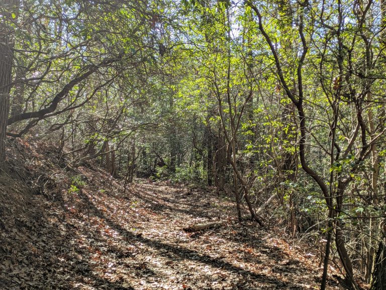
Either way, the hike was still beautiful on a cold February day. The closed road ends in a creek bottom with clear views and a strong creek.


It also runs up on a massive private inholding that had been recently logged. It was pretty ugly.
Thankfully, the trees were well-marked with public / private land signs and I made my way on public land down to a corner marker (the sharp right angle underneath “Bushwhacked” in the map above) near an unknown creek.
At that point, I realized that I was way off trail and basically lost.
From there, I broke out my compass, my cached Google Maps topo map, and my property boundary map.
I figured out where I was and made a plan to walk along the ridge that followed an unknown creek, which was flowing towards Kinnard Creek.
In February, it was pretty easy going. There were clear views and no underbrush. I would absolutely not recommend this bushwhack in summer. If you were in the forest in the summer, you’d absolutely have to stay up in the pine growth above the creek to avoid ticks, mosquitoes, and a whoel ton of brush & briars.

Either way, the path finding added a bit of adventure and eventually I hit Kinnard Creek where there was no clear trail but…there were trail signs!
In some ways, it was bit sad. This trail used to be well-cared for and brand new with a really cool path for horses, bikes & trail running. But it needs either active maintenance or active users to stay in good condition.

I followed Kinnard Creek until the creek crossing.
The ford requires wet feet no matter what time of year. On the other side, the Rush Creek Trail starts and continues on to a hunt camp near Lane Rd about 3 miles away. You could absolutely put together a decent out and back day hike or bike run with the trails.
In fact, I have evidence from the Forest Plan that there is a social path connecting the Rush Creek trail to the Wise Creek Trail which then connects to the 10+ mile Ocmulgee Trail system further south.
So despite the lack of maintenance and sliced up inholdings, it was really cool to imagine a whole 100+ mile system of high-quality unique trails winding through the Oconee National Forest.
I had hoped to continue on, but the path finding had put me way behind schedule.

Plus, I technically had not hiked the Kinnard Creek Trail yet. So I ate lunch and headed back – following the trail signs and yellow paint.

I never saw another person the entire trip, which was pretty special given how close I was to Atlanta and the fact that I wasn’t in designated Wilderness. Now – there was plenty of evidence of people. I saw hidden hunting chairs. Plenty of paint and survey markers. But the forest was quiet and the trail fairly easy to follow in this direction.
Even where the trail wasn’t obvious, the trail signs along this stretch were pretty notable.
There was one service road walk for a few hundred feet, and a pretty massive blowdown – but a close watch for signs showed the way.
For a short hike, the trail went through several variations in forest types. The pines quickly took over the uplands while leaving the creek bottoms to all sorts of hardwoods.

There were a fair number of pretty streams along the way that exposed granite slabs. I could imagine how this land made for a tempting farming area, but would also quickly give way to erosion and abuse.
Even in the winter, there was a decent amount of wildlife. I saw a couple different species of woodpeckers. I nearly ran into several deer.
Overall, it was not the hike that I expected, but it was great nonetheless. There are many reasons why no one hikes the Kinnard Creek Trail as it currently exists.
But there is absolutely no reason why the Kinnard Creek Trail should not better maintained and more popular.
The Superstar Effect is an unfortunate side effect of social media and the Internet in general. When nature goes viral – everyone loses,
The Appalachian Trail, Ravens Cliff Wilderness, Blood Mountain, Tallulah Gorge, etc are all suffering from overcrowding. There are many conflicts between mountain bikers, horses, runners, and hikers in the well-known trails in Georgia.
I plan on coming back to explore the Rush Creek Trail, Burgess Mountain Trail (which was also completely overgrown when I visited last July), and others.
Random Observations
This Forest is tick heaven. Pants are necessary year-round and I’d cover myself with DEET in the summer.
I would not do a first-hike in the Oconee National Forest outside of winter. During the summer, the place must be comically overgrown.
I know that Forest Service funding sucks right now. But it doesn’t have to be that way. I desperately hope that the Forest Service will get more budget for acquisitions. Fewer inholdings would not only make a better experience, but would cut ongoing maintenance costs. In the meantime, hopefully they’ll get more conservation donations and we’ll get some more thoughtful Senators on the Natural Resources Committee.
Hunters love this Forest, which is awesome. I don’t personally hunt or fish, but I am 110% in favor of sustainable, ethical hunting. But wow, you definitely need to be aware of hunting season when hiking.
Never hike in an unknown area without the essentials, especially here. I had (and used) a compass, a physical boundary map print-out from the Forest Service’s Visitor Map in addition to a cached topographic map from Google Maps. You need all three, because you’ll probably lose the trail.
This trail would be amazing on a mountain bike. Maybe the good folks at SORBA will discover it for their next project.
This area is much easier to access from Atlanta than the mountain trails. The sprawl and traffic dies out much faster headed south than headed north.
The Ocmulgee looks like a great river to paddle.
Further Reading
- ReconJasper – amazing research about public lands in Jasper County
- Forest Service Oconee Forest District – official information about the Oconee
That’s all!